After 5 days in San Pedro and a total of almost 3 weeks of doing (almost) nothing, it was time to start the very hard trip to and over the Paso de Jama to Argentina. The Paso de Jama is the bordercrossing between both countries, but to get there you have to cross 2 passes of over 4800 m (14.500 ft). Just as high as the Mont Blanc in France…
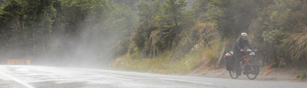
There is nothing there (160 kms, 96 miles till Jama where there also isn’t much food to get and 280 kms, 168 miles to Susques where there’s some food), so you need to bring enough food for 4 or 5 days. You also need enough water, but because you can never carry enough water for that many days the help of truckdrivers is very welcome. It was a hard journey; with heat, cold, exhaustion and beautiful views on saltflats/lakes and mountains with beautiful colors. In the morning we wore almost all the layers we had and during the day we could take them off one by one. Till it got later and colder and we had to put everything back on. We even wore our very warm shoecovers.
San Pedro lies at an altitude of 2440 m (7300 ft) and we had to go to above 4800 m (14.500 ft) in about 40 kms (24 miles)… Very hard. We have never had such a hard time, not even on the Carretera Austral where it seemed that nothing could be harder than that.
The beginning was alright, the altitude was still not interfering too much and the gradient was 5 and 6%. But not for long. After a few kms the gradient went up to 7 and/or 8% and the altitude started interfering. At sealevel that gradient is alright and doable, but at that altitude it was very hard. For the next 30 kms (18 miles) we had to stop every 100 meters (yards!!) to rest and get our breaths back. We never knew that 100 meters could be so long… The trucks were also having a very hard time; they too went very slowly and a whole lot had problems with their engines.
At the end of the day we had covered the great distance of 33 kms (19 miles), 20 kms (12 miles) of which were uphill. We were on the road at 9 am and we stopped at 5 pm to find a spot to camp. It had been a long, hard day.
The next day we had to cycle another 12 kms (7 miles) uphill, the same way as the day before. We were so happy when we finally reached the point where the steep part should end. From there on it would get a bit easier according to the description we had. But no, we did go downhill for a short while, but then steep up again and it went on like that for a while. When we were at the top, our computers showed an altitude of 4685 meters (14.000 ft), but according to gps measurements it should be 4833 meters (14.500 ft) high. That meant we had cycled up the Mont Blanc in France!
We had cycled 42 kms (24 miles) that day and when we went looking for a good spot to camp it was already almost 5:30 pm and we were still above 4600 meters (13.800 ft). We were so exhausted that we really didn’t have the energy to pitch the tent and cook dinner, but of course we had to do that. By then it had gotten really cold, it was only 2˚C (33F). Cooking became a very cold chore. The next morning it was -10˚C (14 F) inside our tent! There was ice in our waterbottles and on the innertent and there was also a thin layer of ice on our sleepingbags and clothes. But we weren’t cold ourselves, we have good gear.
So it wasn’t an early morning that morning, we didn’t want to get out of our warm sleepingbags. But that day turned out to become a great day. Finally the steep part ended a bit and we actually went downhill and flat for a while. We could finally make some kms. And enjoy the beautiful world over there, because it is absolutely beautiful up there! Beautiful colors and saltlakes with bright white salt and beautiful colored water, mountains and large sandflats. We still had to pass 4800 meters (14.500 ft) again, but then the really steep climbing was finished.
The next day also was a lot less hard, even though the high altitude did play a big role and it still wasn’t easy by far. But these days we were able to make some kms. We spent a total of 4 days above 4000 meters (12.000 ft). There wasn’t much traffic, so most of the time we were all alone up there. Especially at night we had the whole place to ourselves. And there was just nothing there; no town, no huts, absolutely nothing. Also no water. We got our water from friendly truckdrivers. We just stood on the road and waved in order for them to stop. They are always very helpful and friendly.
After 4,5 days we finally arrived at the Argentine border, in the little town of Jama! We were so happy and proud of ourselves that we made it, despite the many tempting moment to turn around to San Pedro! There’s a gasstation in Jama where we had a sandwich and drank a whole bottle of Coke. Such luxury after 4 days of nothing special. But we were so tired that we didn’t even notice much of that Coke…
It was only 1 pm, so we decided to go on even though it was very tempting to stay there, pitch the tent somewhere and have a shower at the gasstation. But it would be a waste of time, also because we only had food for 1 more day and there was nothing to buy in Jama. And the next 90 kms (54 miles) would be flat before it would go up again. We were able to cycle another 60 kms (36 miles) that afternoon, despite the stormy sidewind. Then we saw a good spot for the tent and pitched it there. Every afternoon the wind picks up till stormy proportions and dies down when it’s dark and cools down, but fortunately the wind usually is west which means we had tailwind almost all the time.
The last day to the little town of Susques (and the first real sign of civilization) was not very long. We only had to cycle 55 kms (33 miles), of which 11 kms (6,5 miles) not very steep uphill. And we had an awesome downhill of about 20 kms (12 miles) to the town. So we arrived there nice in time. This time we didn’t continue, but checked into a hostal and had a wonderful and long shower. Finally a shower, after 5 days… And a look in the mirror. Our faces were blackened by the sun which is very strong at such high altitude. And it shone constantly. The imprint of our sunglasses was very visual. Of course we bought another bottle of Coke and drank it. We definitely deserved it! Now we had really survived the whole ordeal and there was only a stretch of about 2 days ahead of us with only 1 pass of 4195 meters (12.500 ft), coming from 3410 meters (10.200 ft). But that was about 145 kms (90 miles) which we should be able to cover in 2 days because a lot went downhill.
We also decided we deserved a day of rest and stayed in Susques for a day. A very strange town with houses/shacks of some sort of clay. There’s a very cute and old little church (from 1598) but unfortunately we couldn’t go in. The people look like the people in Bolivia with a very dark skin and the women wear the same hats. But then again, we were very close to the Bolivian border.
From Susques it was about 145 kms (90 miles) to real civilization, to very touristic Purmamarca which lies on the base of beautiful colored rocks. It went up immediately, but then followed a part downhill and many boring flat kms. We also had a headwind there, so we weren’t too happy. We camped right after the large saltflat Salinas Grandes, right before the road went uphill again. We had a beautiful view on the saltflat and the sunset over it. So the next day started with 26 kms (15 miles) of uphill. Then we were at the top and looked down on an awesome 40 kms (24 mile) downhill to Purmamarca, switchbacks as far as we could see. Now we really had made the Andes crossing. Had a drink and something to eat in Purmamarca and, because it was still early, then decided to continue another 25 kms (15 miles) to Tilcara, a little bit to the north. Of those 25 kms, 22 (13 miles) were uphill, but it was doable.


We found a hostal in Tilcara and got our own little cabin/house. We decided on another restday there. We wanted to go to Salta to do a loop of about 500 kms (300 miles) there through a (supposedly) very nice area. But that meant that we would have to cycle about 200 kms (120 miles) to the south and return that same stretch back to the north. Fortunately we could leave a lot of things behind in the hostal so we could travel light, with only the things we would need for that short detour. We need to go back to Tilcara anyway because it’s on the route to Bolivia.
The first 85 kms (51 miles), to San Salvador de Jujuy, were almost completely downhill. We started at about 2400 meters (7200 ft) and Jujuy is on about 1200 meters (3600 ft). We couldn’t really enjoy the downhill because it was storming and part of it we had a headwind. Also, we knew that we would have to go back the same way which meant having to cycle it all uphill again. And that would be a hard ride…
We covered the 200 kms (120 miles) to Salta in 2 days, the way back is going to take a bit longer…
Wauw, wat een verhaal. Kanjers zijn jullie..