The last stretch of West Coast took us to Westport. It’s a beautiful coast, with tropical vegetation. Also, there are the ‘Pancake Rocks’, rocks that look like stacked pancakes.
From Westport, we went back inland through the Buller Gorge to the small town of Murchison which is known for rafting and kayaking. We arrived on a Wednesday and were told that that coming weekend there would be a big festival with raft and kayak competions and games. Unfortunately, we didn’t have time to stay that long. We wanted to go kayaking ourselves, in Abel Tasman National Park, and after that we would still have a lot of cycling to do before we can take the ferry to the North Island.
The next morning, the weather had deteriorated and it started raining while we were having breakfast. We decided to wait it out, but it kept raining so we decided to stay and pitched the tent again. So we had an unplanned restday and when it finally stopped raining, the rest of the afternoon was pretty good.
Because we stayed in Murchison that extra day, we wanted to try to do the 130 kms (80 miles) to Motueka in 1 day. We originally planned 2 days for it, so this way we would make up for the restday. We had to go over many hills and a pass again, but after that most of it went downhill. The last part, we cycled through many different orchards; pears, apples and many other fruits are grown in that area. It was a pretty long day, but we made it.
Motueka is a very touristy town and the gateway to the Abel Tasman National Park. From there you can book many things, but mainly kayaking and hiking. Next to the campground was a kayakrental company, so we went there the next day. Very close, so nice and easy. We rented a kayak for 3 days and booked the watertaxi and campgrounds for 2 nights. We were going to be taken to a certain beach by watertaxi and then paddle back in 3 days. This way we wouldn’t have to do the same stretch twice and we would have the wind in our backs.
We left the next morning; we had to be at the rental company at 7:45 am. We were given a kayak, life jacket, spray skirt, flairs, and bilge pump and tried if all our gear fit inside, which it did. We were taken to the town of Marahau, from where all the kayaks leave. We got another briefing and could try the kayak. When everything was okay, everything was loaded into and onto a watertaxi and we left.
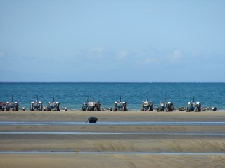
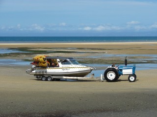
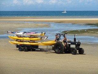
The watertaxi’s are being pulled to the water behind tractors. That’s necessary because the water gets so low at low tide that it’s a long way to get there and the boats can’t get to shore. The people get on the boat while still on shore and it’s driven to the water by a tractor. When it’s deep enough, the boat is released and can turn on the engine. The kayaks are also loaded on these boats.
We were dropped at the beack of Onetahuti and from there we were on our own. We packed everything in the kayak and left after we had lunch on the beach. We went North first, before we went back South and went to the first campground. Paddeling went fine and the weather was beautiful. We saw birds and a few big rays in the shallow waters of a beach. The campground could only be reached over the water, so there were only kayakers. Most campgrounds can also be reached by hikers who hike the Abel Tasman track. After a dip in the cold water, the day was almost over and the sandflies came out to hunt us…
The next day started cloudy, but it cleared pretty quickly and it was beautiful the rest of the day. We paddled to the next campground and arrived early. We pitched the tent, left our stuff behind and went back on the water. We crossed to a large island where we saw seals. Most of the adult seals were at sea, hunting for food, but we did see some very tiny ones. Very cute.
On the way back to the campground, the wind picked up. It got really windy and (of course) we had a headwind. The sea turned rough and very choppy, the waves hit the kayak from all sides. It was a long way back and paddeling in that wind was a lot harder than without wind and we were happy when we had made it back to the campground. The wind died down in the evening and all became calm again.
After another night on a beach campground, we started on our last day. The sea was calm again and we left around 10 am. We paddled to different small beaches and stopped a few times to enjoy the sun and the beach. A little vacation! We got back to Marahau at 3:30 pm and the kayaks were taken back to shore by tractor. We were taken back to Motueka by van and were reunited with our bikes and other stuff.
Those 3 days at sea were a nice change from cycling and felt a bit like vacation. But after another day in Motueka to restock on supplies, we start a hard stretch of 6/7 days without services. We cycle a bit back south, to St. Arnaud, to start the Rainbow trail from there; about 100 hard kms (60 miles) of unpaved road with a almost 1400 meter (4200 ft) high pass. We cut across to the Molesworth trail and head back up north. The Molesworth trail also is an unpaved route with many steep hills. The panniers are very heavy with all the food we will carry. We could go to Hanmer Springs inbetween the 2 trails, but that would mean another steep 500 meter (1500 ft) climb. So we want to combine the 2 trails.


Mooi verslag. We hebben destijds getwijfeld over een meerdaagse kayaktocht door AT NP. Wegens tijdgebrek niet gedaan. Achteraf wel jammer. Sterkte met het laatste stukje Zuidereiland.
Altijd weer fijn om te lezen…jullie verhalen en t zien van die prachtige foto’s. Maar jaloers. …neeuuhh !! Eggg wel…bah bah. Geniete jullie..
Groet Harrow