After a rainy and stormy day in Dunedin, we left to go inland again on a cloudy morning. We hoped the weather would be better there. And yes, it didn’t take long before the sun came out, the sky turned blue and the temperature rose to around 30 C (80 F). It was a hilly ride to Middlemarch, the most altitude meters till then; almost 1400 (4200 ft) in 85 kms (51 miles). A lot of climbing an a little less descending.


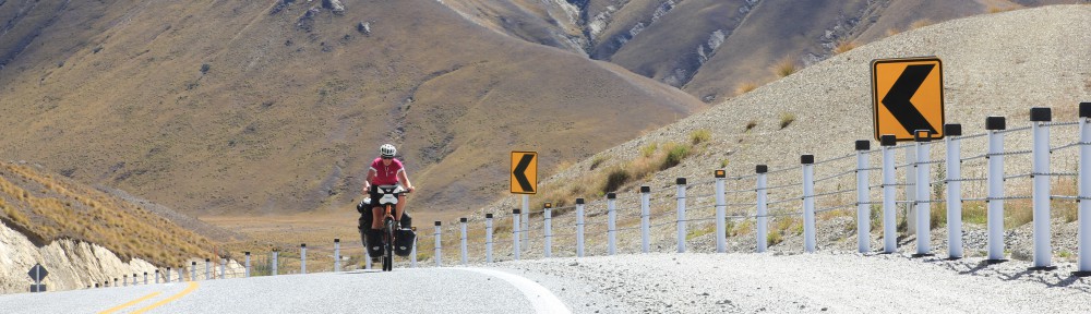
The Otago Rail Trail starts in Middlemarch, a 150 km (90 mile) long route on a previous railroad. The tracks were taken out and gravel was put on the trail. Now it’s a famous, popular and touristic bikerout. Many people ride part of it on a daytrip or ride the whole route in a couple of days. Bikes can be rented from both sides of the trail and when you only want to do part of it, you’ll be taken to from where ever you want to ride and can ride back (usually downhill). There is accomodation everywhere, so every day you can go as far as you want. It’s an easy route, half of it does go up but never more than 2%. So it’s do-able for everybody and we did meet many other cyclists.


We spent the night in Wedderburn, a very small settlement halfway the route. A beautiful place with a great view. We had cycled uphill all day which meant the next day we only had a few kms of uphill to go. Then almost everything was downhill to Alexandra. The last 8 kms (4,5 miles) to Clyde were flat. There, after 150 kms (90 miles) without traffic accept other cyclists, the trail ended and we had to go back on the road. We decided to continue to Cromwell, so the next day would be less long. Those last 22 kms (13,5 miles) to Cromwell we had a stormy headwind and therefor were not easy.
After Cromwell we had to go over another pass, the Lindis Pass. Fortunately the wind had changed so we had a tailwind. After another long and pretty gradual start, the last part was very steep again. But the pass in general was not too bad. A long and gradual downhill followed and then a flat stretch with full sidewind till Omarama. There we were reunited with Vincent and Jeanette. We would spend the next days with them.


Then it was only one day to get to 3755 meter (11.265 ft) high Mount Cook, the highest peak in New Zealand and Australia. The Maori’s call the mountain Aoraki, which means Cloud Piercer. It was a cloudy day, but the weahterforecast was promising for the coming days, so we decided to go even though we had to cycle the same 60 kms (36 miles) back when we would leave.
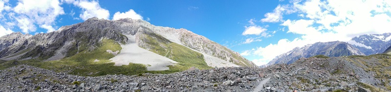
Panorama
And it proved to be absolutely worth it! The campground is a beautiful and quiet place despite of it being very busy. After a cold night, the next day started cloudy again but it didn’t take long for the sun to break through the clouds. We didn’t see Mt. Cook itself that day, it decided to stay in the clouds, but the weather was great. We had already decided to stay 2 days and that last day was absolutely great. Bright blue skies and the mountain was completely visible.
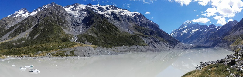
Panorama Cook
We walked to a glacier lake both days to have a good view on the mountain.


Because we didn’t see the mountain on our way over, we looked over our shoulders a view times on the way back. The weather was still great, so it was completely visible. Together with the beautiful blue water of Lake Pukaki, it was a beautiful sight. We rode to Lake Tekapo on an mostly unpaved and carfree route. The next day we said goodbye to Vincent and Jeanette, they were going to go in a different direction from there to end up in Christchurch for their flight home. We’ll be going further north.


